Eleven miles of trail buys every big view in southern Utah's park country. That is the total walking distance across all nine hikes, and the longest single one is 1.8 miles.
Most people driving into Zion or Arches carry one assumption: the postcard shot needs a long, steep climb or a full day committed to a single trail. The numbers refuse it. Canyon Overlook is 1.0 mile round trip, 160 feet of gain, about an hour. Mesa Arch is 0.7 mile and 80 feet. Even Queens Garden, the longest here, sits at 1.8 miles with 320 feet paid on the way back out.
Each entry below treats the walk as a purchase: exact trailhead, distance, gain, time, and the formation or canyon it buys you.
By the end you can pick by area and situation, and know your first-morning hike before you sleep.
Quick Tips Before You Start
Carry two liters
Even a one-mile desert trail dehydrates you faster than the distance suggests; the dry air hides sweat.
Start before nine
Almost every trailhead on this list has little shade, and the parking fills by mid-morning in summer.
Wear real tread
Slickrock and hoodoo trails are uneven underfoot; running shoes work, flip-flops do not.
Check the pass
Zion, Bryce, Capitol Reef, Canyonlands and Arches each charge an entrance fee; Snow Canyon and Kodachrome are Utah state parks with their own.
Give yourself the listed time
The times here are round-trip walking plus photo stops, not the driving between areas.
1. Petrified Dunes Trail in Snow Canyon

Petrified Dunes Trail is the red-rock panorama you can walk in under an hour. From the Snow Canyon trailhead, the route runs 1.2 miles round trip with about 100 feet of gain, and 45 minutes to an hour puts it back at the car.
The path crosses slickrock and the fossilized sand dunes that give it the name, then opens onto red Navajo sandstone, black lava flows and the Pine Valley Mountains all in one sweep. Go early morning or late afternoon, when the low sun turns that sandstone the color you came for and the dark lava reads as contrast instead of shadow. What the 1.2 miles and 100 feet buy is a panorama rather than a single framed viewpoint, which suits kids and a quick stop out of St. George, and keeps the whole thing inside a half-day.
💡 Tip: Park at the Petrified Dunes trailhead inside the park, not at the visitor center; the walk from there adds distance you don't need.
Petrified Dunes Trail — At a Glance
📍 Trailhead
West Canyon day-use parking, off Snow Canyon Drive
🧭 Route type
Out-and-back on open slickrock — no marked path, follow the cairns
🎫 Entry
State park day-use fee per vehicle; Utah state parks pass covers it
🥾 Surface
Bare sandstone and sand — grippy shoes, no shade
🌧️ Skip if
It rained in the last 24 hrs — wet slickrock gets slick and the sand clumps
Why it beats the other eight
Only stop on this list where the view is 360 degrees and you can wander off-route instead of queueing at a railing.
2. Canyon Overlook Trail Above Zion
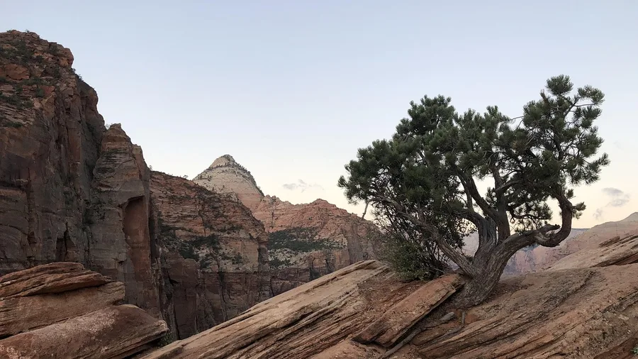
One mile round trip, 160 feet of gain, about an hour. That is the whole climb for Canyon Overlook, and the trailhead sits just east of the Zion-Mount Carmel Tunnel, where the roadside pullout fills early because everyone has read the same thing.
If the Snow Canyon walk showed you what a low-buy red-rock view costs, this applies the same arithmetic to the state's signature canyon. The climb is concentrated: a short stretch of rock steps and a ledge cut into the cliff, held with a handrail in places, so you will be breathing hard for maybe ten minutes and then you are finished.
The payoff is a railed ledge with a straight-down view of Pine Creek Canyon, the switchbacks of the highway below and Zion Canyon itself opening north. Sit on that ledge at sunrise and the east-facing walls go orange while the canyon floor stays blue, late afternoon gives you the same light from the other side, and both beat the midday shuttle crush at the canyon trailheads.
The nature move here is a small one and honest about its odds: you are looking down on ravens working the updrafts below the rail, and if you are on the ledge near dawn there is a fair chance of seeing them ride the thermals straight past your feet. No bighorn guarantee, no condor photo, just a couple of black birds hanging in space over a thousand-foot drop.
The 160 feet is repaid in the first ten seconds at the rail. A canyon overlook that usually reads as a half-day hike with a stiff climb behind it comes out of one mile and one concentrated scramble, which is what makes this the Zion stop when the rest of the family is ready to move on.
💡 Tip: Morning sun lights the canyon floor; late afternoon turns the west wall orange. Midday is flat and crowded.
3. Queens Garden Trail from Sunrise Point
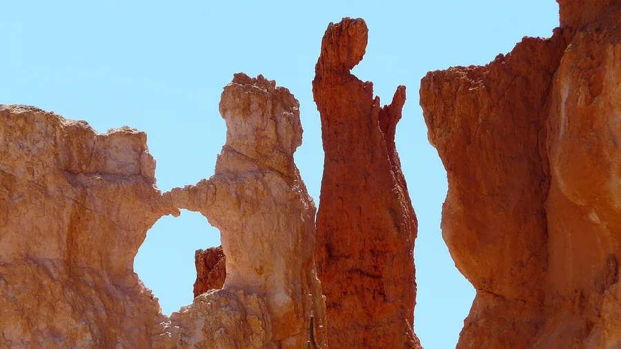
Do the Queens Garden Trail if you want hoodoos close up and only have time for one Bryce walk, but go in knowing the 320 feet is paid on the way back out, not on the way in.
Where a canyon overlook works by looking down, this one trades that for going down: from Sunrise Point the path drops into the amphitheater and puts you at the base of the spires, past the Queen Victoria formation, among rock that towers over your head instead of sitting beneath you. The full loop is 1.8 miles round trip with about 320 feet of gain on the return, an hour to an hour and a half from the trailhead.
That is the catch. The descent is easy and the climb out is short but steady, and it lands at the end of the walk when the kids are done. Start from Sunrise Point and read the gain as a return payment, not a total climb, and it stays within reach of a first Bryce visit that wants the iconic scenery without the whole canyon descent.
💡 PRO TIP
Reverse the Bryce Crowds
Almost everyone starts at Sunrise Point and drops in first. Walk the Rim Trail ten minutes toward Sunset Point and drop in there instead; you meet the same hoodoos with half the foot traffic and come out facing the light.
4. Angel's Palace Trail at Kodachrome
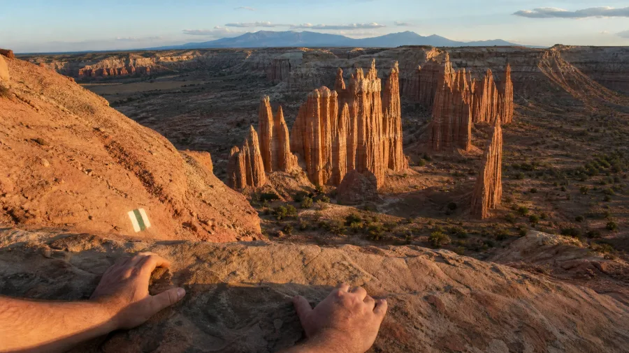
Warm wind carries the smell of juniper up the slickrock, and your boots find the painted trail markers, starting a climb that does not feel like a climb at all. The Angel's Palace trailhead sits just off the park road, and the circuit is fifteen-tenths of a mile with barely a hundred and fifty feet of rise — under an hour, even with a camera stop at every turn.
You gain the mesa top in a handful of switchbacks, and Kodachrome spreads below like somebody tipped over a box of red crayons: chimney spires, fluted towers, and the wide basin that holds them all, with the Henry Mountains hazy on the horizon. The spires are the same shade as Bryce's hoodoos, but you will not fight a shuttle bus to see them.
If you are driving from Bryce toward Capitol Reef, this is the leg-stretch to build in. The 1.5 miles and 150 feet buy you a mesa-top panorama of spire and basin — the same red-rock country, at a fraction of the crowd.
| Hike | Area | Round trip | Elevation gain | Time | View payoff |
|---|---|---|---|---|---|
| Petrified Dunes Trail | Snow Canyon | 1.2 mi | ~100 ft | 45–60 min | Red sandstone, lava flows, Pine Valley Mountains |
| Canyon Overlook Trail | Zion | 1.0 mi | ~160 ft | ~1 hr | Zion Canyon from a railed ledge |
| Queens Garden Trail | Bryce | 1.8 mi | ~320 ft | 1–1.5 hr | Hoodoos and Queen Victoria close up |
| Angel's Palace Trail | Kodachrome | 1.5 mi | ~150 ft | Under 1 hr | Red spires and basin from a mesa top |
| Valley of Goblins | Goblin Valley | 1.5 mi | ~100 ft | ~1 hr | Hoodoos and San Rafael Reef horizon |
| Sunset Point Trail | Capitol Reef | 0.8 mi | ~100 ft | 30–45 min | Waterpocket Fold and Henry Mountains |
| Rim Trail | Dead Horse Point | 1.5 mi | ~50 ft | ~1 hr | Colorado River gooseneck |
| Mesa Arch Trail | Canyonlands | 0.7 mi | ~80 ft | 30 min | Arch framing the La Sal Mountains |
| Windows Loop | Arches | 1.0 mi | ~100 ft | 45 min | North and South Windows, Turret Arch |
5. Valley of Goblins in Goblin Valley
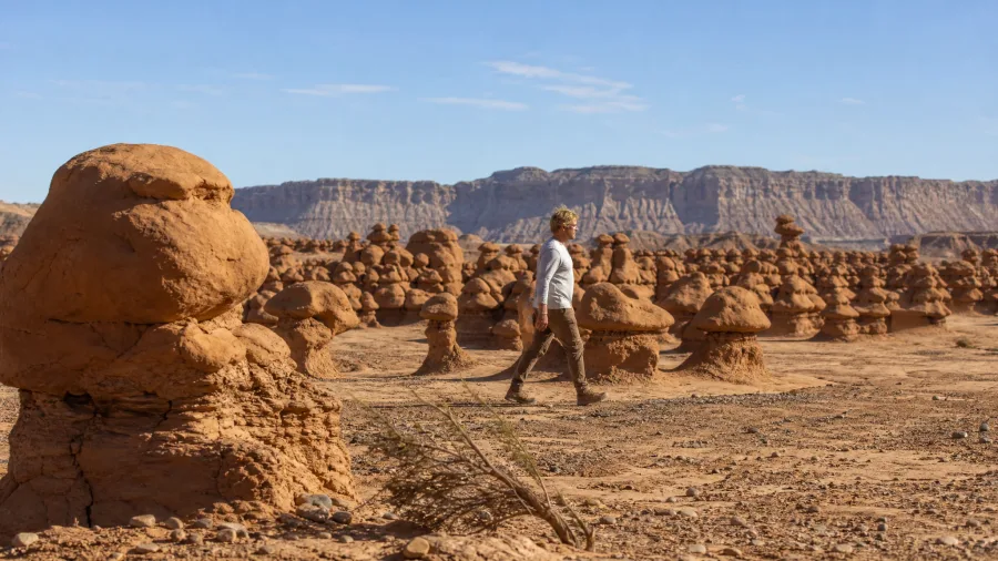
Before you go: there is no trail here, only open rock, so bring water and a way to remember where you entered the valley — the goblins all look alike from inside. The Valley of Goblins trailhead is at the end of the park road, and wandering among the mushroom-shaped hoodoos costs nothing beyond the park entry fee.
Once you are down among them, hundreds of mushroom-shaped figures rise chest-high to three stories, and the San Rafael Reef stretches across a big desert sky. A choose-your-own wander of about 1.5 miles and 100 feet of gain fills an hour easily, and kids and photographers will want more.
Your First Hour at Any New Trailhead
6. Sunset Point Trail in Capitol Reef
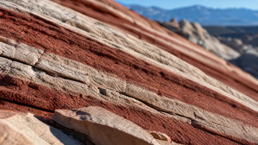
The light at Sunset Point turns the rock a deeper red as the day goes long, and the wind whistling through the narrow slots below the rim is the sound that stays with you. From the trailhead the path is under a mile out and back with only about a hundred feet of climb — thirty to forty-five minutes, even at a kid's pace.
You are standing at the edge of the Waterpocket Fold, the hundred-mile wrinkle where the earth's crust buckled into tilted layers, and you can read the stripes of old sandstone like the rings of a tree. Beyond the fold, the Henry Mountains rise in blue shadows.
It is the shortest walk in the Capitol Reef area, which is why it earns a stop even on a packed day. Sunset is the classic hour, but the fold reads from the rail at any time of day, and the crowd at dusk is mild compared with what you left behind.
Two Ways to Do This Trip
Overlook hop
- Drive to each signed viewpoint
- Ten minutes per stop, photo from the rail
- No shade needed, no water needed
- Sees the canyon, never touches it
- Works if you're moving 300 miles in a day
Short-hike route
- One 30–60 minute walk per park
- Same famous view, from the end of a trail
- Carry water and start before nine
- Stand under the arch, between the hoodoos
- Two or three hikes fit a normal park day
7. Dead Horse Point Rim Trail
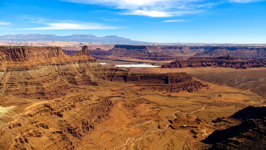
The rim walk here is flatter and easier than the climb to any fold viewpoint, and that is the whole reason to save it for the Moab leg.
Dead Horse Point Rim Trail runs 1.5 miles round trip from the visitor center trailhead with about 50 feet of gain, and it takes roughly an hour at an unhurried pace. The path tracks the canyon edge, level the entire way, until the ground falls away and the Colorado River doubles back on itself below you in a full gooseneck, with the Potash Road cut visible in the rock under the far rim. If you have spent the day in Moab and your legs are done, this is the big view that costs you nothing in climb. The 1.5 miles and 50 feet buy the gooseneck, and 50 feet is not a typo. Arrive an hour before sunset, walk out to the fenced point, and stay put: the river turns copper as the light drops and the far rim goes purple, which is the frame you came for. It is a state park, so there is an entrance fee, and the point can get breezy and cold once the sun is down, so bring a layer.
8. Mesa Arch Trail in Canyonlands
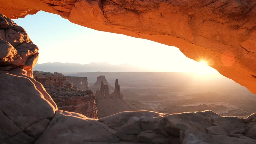
It can, and this is the one.
Mesa Arch Trail is 0.7 mile round trip with about 80 feet of gain from the Island in the Sky trailhead, and 30 minutes covers it comfortably. At the end, a low stone arch sits right at the rim and frames the La Sal Mountains across a drop into the White Rim canyon country, so the photo is arch, mountains and canyon all in one window without a climb worth mentioning. It suits anyone who can walk a short, uneven slickrock path with a few rock steps, including kids and grandparents who came for exactly this. It does not suit anyone chasing solitude at dawn: photographers line up shoulder to shoulder along the arch before sunrise, and the front spot is claimed well before first light, so bring a headlamp, arrive early, and accept a shared rail if you want the glow. The arch catches fire underneath when the sun clears the horizon, and that ten-minute window is why people get up at four. The 0.7 mile and 80 feet are a genuine leg-stretch, so treat it as an easy add-on to a longer Island in the Sky drive rather than the drive itself.
💡 Tip: The underside of the arch lights up for only a few minutes after sunrise; arrive 20 minutes early and pick your spot.
9. Windows Loop in Arches
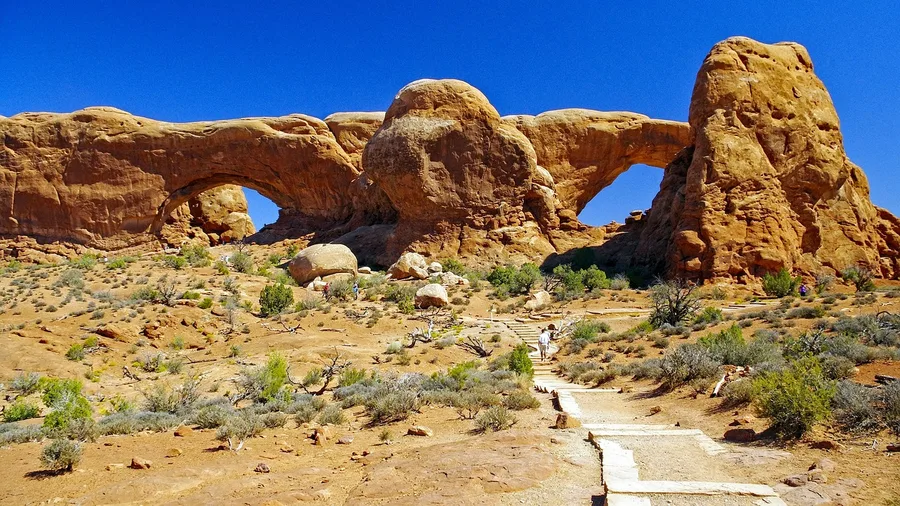
Three of Arches' signature formations sit on a single flat one-mile path, and that is the whole pitch for the Windows section. From the Windows trailhead you walk 1.0 mile round trip with about 100 feet of gain, 45 minutes at an unhurried pace, and the La Sal Mountains stay in the frame behind the stone the entire way.
North Window first: a hole roughly the size of a house punched through a sandstone fin, with a ledge you can stand on while the light comes through behind you. South Window sits a few minutes further on the same loop, and Turret Arch closes it out, a tower with a window cut clean through its middle. Families do this one in sneakers and a water bottle because there is no long desert approach to survive. The 1.0 mile and 100 feet buy all three formations in one short loop, and for a first Arches visit that is the best return on a tank of gas in the park.
🗺️ Build a Two-Day Short-Hike Route
Day 1, morning
Start at Snow Canyon's Petrified Dunes out of St. George, then drive to Zion for Canyon Overlook before 8 a.m.
Day 1, afternoon
Drive Highway 89 to Bryce and walk Queens Garden from Sunrise Point before the light drops.
Day 1, evening
Stop at Kodachrome's Angel's Palace loop on the way east, or save it for the morning.
Day 2, morning
Detour to Goblin Valley for the Valley of Goblins, then push to Capitol Reef for Sunset Point.
Day 2, afternoon
Drive to Moab and take the Dead Horse Point Rim Trail for the gooseneck at golden hour.
Day 2, last light
Finish with Mesa Arch or the Windows Loop if you still have daylight and legs.
Frequently Asked Questions
Can you really see Zion, Bryce and Arches on short hikes?
Yes, if you pick the right trails. Canyon Overlook gives you the Zion Canyon view in a mile round trip, Queens Garden puts you among Bryce's hoodoos in 1.8 miles, and the Windows Loop covers three Arches formations in 1.0 mile. None of them requires a long climb.
Which of these hikes is best with young kids?
Valley of Goblins in Goblin Valley, without much debate. There's no fixed trail, the hoodoos are close to the ground and climbable, and the round trip is about 1.5 miles with 100 feet of gain. The Windows Loop in Arches is the next easiest sell.
Do I need a shuttle reservation for any of these?
Not for Canyon Overlook, which is outside Zion Canyon itself, and not for the Bryce, Capitol Reef, Canyonlands, Arches, Goblin Valley, Kodachrome or Snow Canyon trails. Zion Canyon Scenic Drive does require shuttle use in peak season, which is another reason Canyon Overlook is the efficient Zion pick.
How much elevation gain is too much at altitude?
Bryce's Queens Garden is the one to watch: 320 feet of gain on the return, starting above 8,000 feet. If anyone in your group struggles with altitude, do it slowly and give it the full 1.5 hours. Everything else on this list stays at or below 160 feet.
When is the best time of year for these short hikes?
Spring and fall for Snow Canyon, Goblin Valley and Moab, where summer afternoons regularly top 100°F. Bryce and Kodachrome sit high enough to be pleasant in summer. Winter closes some roads and leaves snow on the Bryce trails, so check conditions before driving.
How long do I need for all nine?
About eleven miles of walking spread over two very full driving days, or four comfortable days. Realistically, pick four or five that sit on your route. Doing all nine in one trip means six or more hours in the car each day.
The Hour Before the Crowds Arrive
Nine trails, none longer than 1.8 miles, none gaining more than 320 feet, every one finished in under an hour and a half. That is enough to fill a low-effort day with one park's short walk, or to stack two easy stops before lunch.
Choose by the morning in front of you. Sunrise: Mesa Arch. Kids: Valley of Goblins. From Moab: Dead Horse Point Rim Trail. From Zion: Canyon Overlook. From Bryce: Queens Garden.
One morning only? Take Canyon Overlook. One mile round trip, 160 feet, about an hour, trailhead east of the Zion-Mount Carmel Tunnel, and a straight-down view of Zion Canyon. The climb you feared was never the price of admission.
Start With the Mile You Have
Scan the table at the top, pick the hike that matches tomorrow's route, and set your alarm for an hour earlier than you planned.