The walls close to shoulder width, the sky narrows to a blue ribbon, and the temperature drops ten degrees in twenty steps. That moment is Buckskin Gulch, and it costs you a drive, a permit check and an early alarm, not a shuttle queue. Your Grand Canyon itinerary already has the big view. It also has the rim crowds and the timed entries, and that is what sends you looking. The same scale exists off the shuttle system: Buckskin's 20-foot slot, Santa Elena's 1,500-foot limestone walls, Awa'awapuhi's 2,500-foot drop to the Na Pali Coast.
Pick a canyon by distance, effort, season and base rather than by park fame, and the crowd logistics simply disappear.
Eight hikes across Utah, Arizona, Texas and Hawaii, from 1.7 miles to 8, with gains up to 700 feet and descents to 1,600. You can take an easy half-day, a slot-canyon fix or a big-view payoff, and you know to call the land manager about conditions before you commit.
Quick Tips Before You Start
Check the sky first
Slot canyons flood from rain that fell miles away. If storms are forecast anywhere upstream, pick a rim hike instead.
Carry more water than feels reasonable
Three liters per person on any exposed hike here; the desert drainages give zero shade.
Download the map offline
Cathedral Wash and West Fork both have route-finding and no reliable signal at the trailhead.
Grip matters more than ankle support
Slickrock and wet creek stones reward a sticky rubber sole over a stiff boot.
Top off the tank before the last town
Kanab, Sedona and Terlingua are the last reliable fuel stops on these routes.
Know the land manager's rules
Some of these trailheads need a permit, a park pass or a day-use fee. Check before you drive.
1. Buckskin Gulch's Narrow Slot Corridor
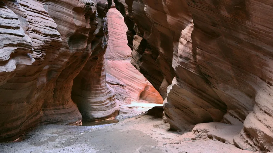
The first thing that registers is the temperature drop, then the walls closing until your shoulders could almost touch both sides and the sky is a thin bright ribbon overhead. That is Wire Pass delivering you into Buckskin Gulch, and it happens within the first hour rather than the last, which is the whole case for this one: the slot comes early and keeps giving. From the Wire Pass trailhead near Kanab the route runs roughly 8 miles out and back to the confluence, about 700 feet of gain spread across the day, and there is a fee at the trailhead for the Paria Canyon-Vermilion Cliffs permit area, so budget for it and check the current rate before you drive out; figure on a long, cool, shadowed half-day rather than a quick stop.
💡 Tip: Wire Pass trailhead is dirt and fills early on spring weekends. Arrive before 8am or expect to walk in from the overflow pullout.
| Hike | Location | Distance / gain | Best season | Standout feature |
|---|---|---|---|---|
| Buckskin Gulch via Wire Pass | Near Kanab, UT/AZ | 8 mi out-and-back / 700 ft | April–June, Sept–Oct | 20-ft-wide slot walls |
| Little Wild Horse Canyon | Near Goblin Valley, UT | 8 mi loop / 700 ft | April–June, Sept–Oct | Twisting narrows and red reef walls |
| Cathedral Wash | Near Lees Ferry, AZ | 3 mi out-and-back / 600 ft descent | March–May, Sept–Nov | Slickrock drainage to the Colorado River |
| White House Ruin Trail | Canyon de Chelly, AZ | 2.5 mi out-and-back / 600 ft descent | Year-round | 1,000-year-old cliff dwellings |
| Lighthouse Trail | Palo Duro Canyon, TX | 5.6 mi out-and-back / 500 ft | October–April | 80-ft red rock spire |
| Awa'awapuhi Trail | Waimea Canyon, HI | 6.4 mi out-and-back / 1,600 ft descent | May–September | 2,500-ft drop to the Na Pali Coast |
| West Fork Oak Creek | Sedona, AZ | 6.4 mi out-and-back / 300 ft | March–May, Sept–Nov | 1,000-ft walls and creek crossings |
| Santa Elena Canyon | Big Bend, TX | 1.7 mi out-and-back / 200 ft | October–March | 1,500-ft limestone walls |
2. Little Wild Horse's Twisty Slot Loop
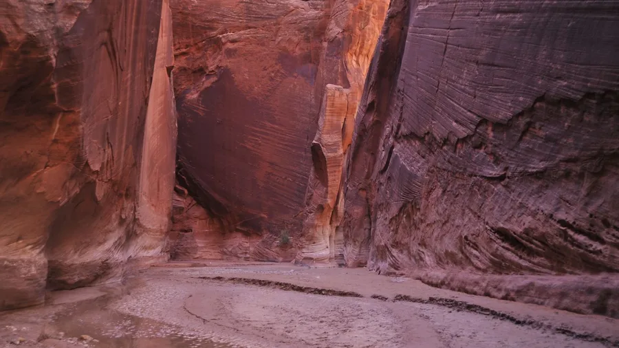
Go here if you want the slot-canyon half-day without committing to a through-hike. Little Wild Horse, out by Goblin Valley, is the loop version of the experience: about 8 miles round, roughly 700 feet of gain, and it keeps handing you narrow passages and red reef walls instead of saving them for one climax. The trade is that the tight sections are sandy and you will be scooting and ducking more than striding, which slows a loop that looks modest on paper.
The format is why it earns the day. A loop means every mile is new ground, so the narrows keep arriving in waves rather than one corridor you reverse at the end, and the Goblin Valley base puts you near hoodoo country for an afternoon. Spring and fall, April through June and September into October, are the windows that match a slot-canyon objective; summer heat in a sandy box is the wrong call.
This one is popular, and honestly so: the trailhead lot can fill on a weekend morning, so start early. Your reward is repeated narrows on a loop with no shuttle and no rim queue, which is the crowd-free calculation working in your favor. Check conditions with the land manager first, since flash-flood risk closes these canyons without warning.
⚠️ COMMON MISTAKE
Never enter a slot with rain in the forecast
Slot canyons flood from storms you cannot see or hear. If there is any rain forecast within roughly 30 miles upstream, save Buckskin and Little Wild Horse for another day and hike a rim trail instead. The rangers at the Kanab visitor center will tell you straight.
3. Cathedral Wash's Route to the Colorado
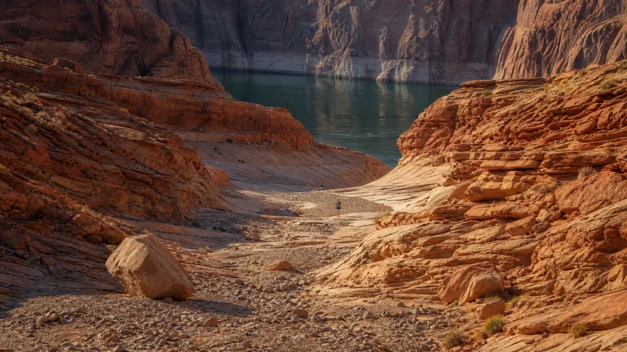
The air cools as the slickrock walls rise around you, then the drainage opens and you hear the Colorado before you see it, a low steady rush of water pushing through a gorge. Cathedral Wash, near Lees Ferry, is roughly 3 miles out and back with about 600 feet of descent to the river, so the payoff is not a viewpoint over a canyon but the water itself at your feet. That is the shift this route makes: after the tight-walled loop, the same short half-day logic lands you in a river gorge instead.
The descent is the work. Slickrock ledges step down toward the river and a couple of stretches ask you to read the route rather than follow a defined path, which is part of the half-day's charm and part of its caution. Spring through early summer and again in fall, roughly March to May and September into November, keep the ledges comfortable; summer heat on exposed rock is not the time.
Finish the loop of the trip here and then eat. Lees Ferry is the put-in for Grand Canyon river runners, a small outpost where you can find a cold drink and a plate of something honest, a burger or a plate of fries, in the range of $12 to $18 depending on where you stop. Check current hours before you count on it. A river-level gorge, a cold drink after, and no rim shuttle anywhere in the equation.
💡 Tip: Follow the cairns, not the cairn-like rocks. Where the wash splits, stay in the main drainage and keep working downstream.
4. White House Ruin Trail's Cliff Dwellings
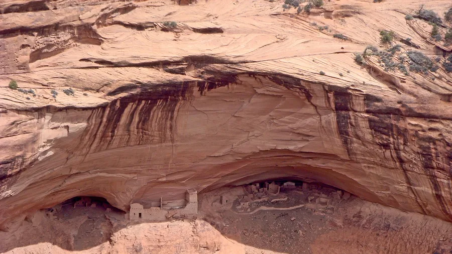
A slickrock drainage drops you to a river in three flat miles; this one drops you 600 feet to a canyon floor where a thousand-year-old village sits against the cliff, and it takes two and a half miles to do it. Both are short, both are steep-ish, both ask for a half-day. Only one puts architecture in the frame.
White House Ruin is the only trail in Canyon de Chelly that you can walk down without a Navajo guide, and that is the whole reason to build a morning around it. The path leaves the rim at the Spider Rock overlook road, switchbacks down the north wall through a tunnel cut in the sandstone, and unloads you on the flat cottonwood floor of the canyon. You descend about 600 feet over the first mile. Kids do it. Grandparents do it slowly, and the return climb is the part everyone remembers.
The photograph you came for is straight ahead and slightly right when you reach the bottom: a shallow alcove in the red wall holding a pueblo of maybe sixty rooms, pale stone against darker rock, a few ladders still in place. Stand at the fence line, not behind the interpretive sign. Late morning puts the alcove in full light; early afternoon throws it half into shadow. The ruin is a working archaeological site, so you look from twenty or thirty feet back, and the rangers mean it.
It is open year-round, which makes it the one hike on this list you can slot into a winter road trip. Check at the visitor center before you drive in, because the road down needs to be graded after storms and a wet week can close it. There is no shuttle, no timed entry, no queue at a gate. You park at the trailhead, and the crowd is however many cars beat you there. Arrive before nine and that number is small.
This is the history stop, and it earns its place on that count alone. If you have a reader in the car who tolerates scenery but lights up at old buildings, this is the one they will talk about at dinner. The canyon handles the rest.
💡 Tip: Navajo vendors sell fry bread near the overlook above the trail. Bring cash, roughly $10, and eat it while looking at the canyon.
Pick Your Canyon Hike by What You Want
Four kinds of payoff, sorted from the niche to the broad
Tailor this to your trip, not to the list order.
5. Palo Duro's Lighthouse Rock Trail
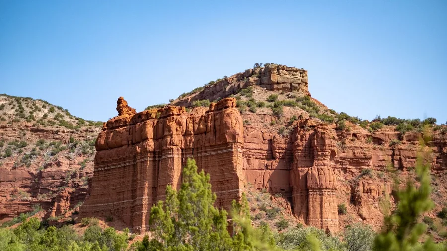
The Lighthouse Trail is a 5.6-mile out-and-back across the floor of Palo Duro Canyon to an 80-foot red rock spire, with about 500 feet of gain spread so gently you notice it mostly on the way back.
You walk it rather than admire it: gravel path, mesquite, the odd horned lizard skittering off the track, and the Panhandle sky taking up more of the frame with every mile, until the spire stands above you as the turnaround. Base is the canyon itself, so you are camped or lodged down in it, not driving in from Amarillo. Best October through April, when the Texas sun is a companion rather than an opponent. Families and road-trippers get a big-view half-day here without a shuttle queue anywhere in sight.
Same Big Canyon, Very Different Crowd
Grand Canyon Rim
- Shuttle queues at peak hours
- Trailheads filled by mid-morning
- Timed entry and park traffic
- Views from a guardrailed edge
- Facilities everywhere
These Eight Trails
- Drive-up trailheads, first-come parking
- Trails that stay quiet midweek
- Permits or day fees, no shuttles
- Views from inside the canyon
- Carry everything you need
6. Awa'awapuhi Trail's Na Pali Drop
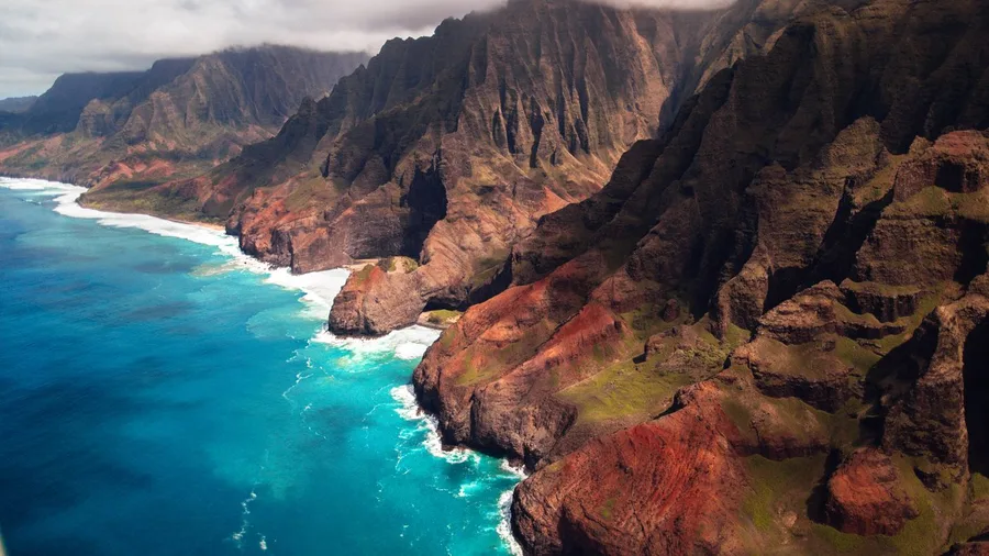
On Kauai, yes, and the price is paid in elevation. Awa'awapuhi starts along the rim of Waimea Canyon and ends on a ridge that simply gives out above the Na Pali Coast.
The trail runs 6.4 miles out and back with 1,600 feet of descent, and the finish is abrupt: you break out of the trees onto a bare ridge and the ground falls 2,500 feet to the ocean. The honest likelihood of seeing the drop is the thing to plan around. Clouds pour into the valley without warning, and a clear start can be a white wall by the time you reach the end. Go early, in the May to September window, and take the view whenever it shows itself rather than counting on it at the terminus.
Fit hikers only. The walk down is pleasant and the walk back up is the whole workout, so budget water for the climb and legs for it. What you trade is canyon crowds for a coastal cliff finish no rim railing can match.
💡 Tip: Bring a light rain shell. Trade-wind weather on that ridge can change in 20 minutes, and the trail gets slippery on the exposed sections.
Crowd-Free Canyon Trailcheck
Blanks are trips you haven't planned yet, not trails you should skip.
7. West Fork Oak Creek's Shaded Narrows
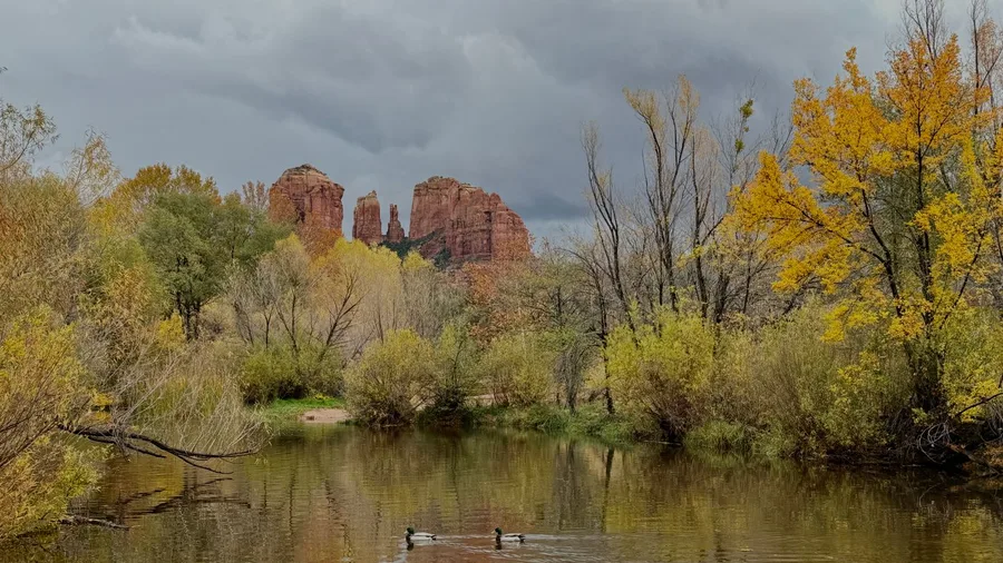
Six point four miles for three hundred feet of gain. After the lung-burning climb back out of a coastal canyon, West Fork Oak Creek is the day you spend standing in water instead of grinding up a wall. The canyon floor here sits low, the walls run about 1,000 feet overhead, and the route stays nearly flat the whole way in.
You start from the Call of the Canyon day-use area off Highway 89A, and there is a fee to park. Check current rates before you go, because they change. From the trailhead the path drops toward the creek almost at once and then follows it upstream, crossing the water again and again on stepping stones and logs. Some crossings are dry-shod; others put you ankle-deep. This is the moment the hike makes its case: red sandstone rising straight from both banks, oak and pine leaning over the water, and the air ten degrees cooler than the road you left.
The story worth knowing is the name. This is the West Fork of Oak Creek, and the whole drainage is a canyon that has been cutting its bed for millions of years while the walls around it eroded back into the shape you see now. That flat floor is why the walking comes easy – a creek wears a channel, not a cliff.
The narrows at the far end are where the walls pinch in close and the creek fills the gap between them, and the walk stops being about distance and becomes about enclosure. You will not get a rim view here. You get something different: the sense of being inside the rock rather than above it, with 1,000 feet of sandstone pressing in on both sides and the water loud in the quiet.
Aim for March through May or September through November. Summer is hot, and the creek crossings can run high after rain – check conditions with the Forest Service before you commit. Allow around four hours for the full out-and-back, more if you stop. The gain is so slight you will barely notice it, which is exactly the point: a dramatic canyon day that asks for shade and water instead of lungs.
💡 Tip: Bring trekking poles. The creek crossings are the only tricky part of the trail, and two extra contact points make them trivial.
🥾 Plan Any of These Eight Trailheads
Pick the season
Match the trail to its window: April–June and September–October for the Utah slots, October–March for the Texas canyons.
Pick the base town
Kanab, Goblin Valley, Lees Ferry, Chinle, Palo Duro, Waimea, Sedona or Terlingua; each trail has one clear base.
Check the land manager
Confirm permits, park passes, day fees and current trail conditions before you drive.
Check the weather upstream
Slots flood from storms miles away; read the forecast for the whole drainage, not just the trailhead.
Pack water, grip and a map
Three liters per person, a sticky sole and an offline map cover every trail on this list.
Arrive at the trailhead early
Beat the spring and fall crowds on the Utah slots and the parking crunch at Wire Pass and West Fork.
8. Santa Elena Canyon's Rio Grande Walls
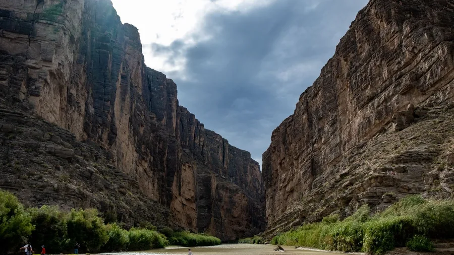
You have to cross the Rio Grande to start, and that crossing is the thing nobody warns you about. At the trailhead the river runs shallow, and you wade it – so go early, before the day heats up and before the light goes flat on the walls. The hour matters here more than the miles.
From the parking area a short switchback climbs the near bank, tops out on a shoulder of rock, and drops you into the canyon mouth. Then the walls close in, 1,500 feet of limestone rising almost straight from the water on both sides, and the whole route in is only 1.7 miles out-and-back with about 200 feet of gain. You get the full gorge feeling – the sound of the river bouncing off the rock, the sky narrowed to a strip, the walls so tall that the light only reaches the water for part of the day – in under two miles of walking.
October through March is the window. In summer the heat and the low water make it a different, harder hike. Go in the morning and the canyon stays cool and shadowed; go late and you catch the walls catching the low sun. Either way, ask the park about river levels and trail conditions before you set out, because a shallow crossing can turn deep fast. Base yourself in Big Bend and this is the short, dramatic canyon walk that costs you almost nothing in effort.
💡 Tip: Do not attempt the crossings when the Rio Grande is high. The river is the border; stay on the marked trail and do not cross.
Frequently Asked Questions
Is it worth skipping the Grand Canyon for these?
Not skipping it forever, but for a specific trip, yes. If you have 3 days and want big rock without shuttle queues, two of these hikes deliver more time in the canyon and less time in a line. Save the Grand Canyon for a longer trip you can plan around the crowds.
Do I need permits?
Depends on the trail. Some land managers require day-use fees, park passes or permits for these trailheads, and slot canyons in particular can have restrictions on group size or access. Check with the land manager before you drive out.
Can a beginner do these?
Four of them, yes: White House Ruin Trail, Santa Elena Canyon, West Fork and the early part of Lighthouse Trail. The Utah slots are manageable but narrow and sandy. Awa'awapuhi is for fit hikers only, because of the 1,600-foot climb back out.
When should I avoid the slot canyons?
Any time there is rain forecast for the region, and especially in July and August during monsoon season. Flash floods in a slot canyon come from storms you cannot see, and the forecast at the trailhead does not tell you what is happening 30 miles upstream.
How much does a trip like this cost?
Trailheads are free to cheap, with day-use fees and park entry running roughly $15–$35 depending on the park. Lodging is the real cost: budget about $150–$250 a night in Sedona or Kanab, less in Terlingua or Chinle. Fuel is your other line item.
Which one should I pick if I only have one day?
Buckskin Gulch if you want the slot-canyon experience and can start early, or Uncle Jim's if you are near the Grand Canyon and want a canyon without the rim crowds. For a short day, Cathedral Wash gives you the Colorado and a gorge in about 3 miles.
Three Ways to Pick From These Eight
Grand Canyon-scale drama does not require the Grand Canyon's rim. These eight were picked by distance, effort, season and base, and that is the whole filter. For an easy half-day, Cathedral Wash, White House Ruin Trail and Santa Elena Canyon sit between 200 and 600 feet of elevation change, with West Fork Oak Creek as the shaded low-effort variant. For the slot-canyon fix, Buckskin Gulch and Little Wild Horse both run 8 miles with 700 feet of gain, best April to June and September to October, one with 20-foot walls and one with tight sandy narrows. For big-view payoff, Palo Duro's Lighthouse Trail ends under an 80-foot red spire and Awa'awapuhi gives you the 2,500-foot Na Pali drop.
Check current trail conditions with the land manager before you commit. The crowd-free choice still depends on the route being open.
Pick One and Book the Base Town
Choose your hike from the table above, then book the nearest town to its trailhead. That single decision makes the whole trip real.