The mistake to avoid is saving the cliffs for a day you never quite have. A big European coastal view sounds like a long technical hike, a car and a booked guide. It isn't.
Every walk below runs 2.5 to 6 miles with under 500 ft of ascent. All are waymarked, fine in trainers, and need no guide, permit or booking. All ten start within a 10 to 30 minute walk or local bus ride from a town with a train station or a ferry.
how long each takes, what the path is like underfoot, which bus or ferry gets you there, and a cafe or village lunch within 15 minutes of the finish for EUR 10 to EUR 15. Bus singles run EUR 2 to EUR 4 and day parking EUR 4 to EUR 8.
Pick one tonight and do it tomorrow. Carry a litre of water, a sun hat, shoes with tread and an offline map. May, June and September are best; in July and August be on the path before 9am, because car parks and viewpoints fill by 10. A light rain shell earns its place on all ten.
Quick Tips Before You Start
Trainers with tread
Every route is walkable in trainers, but the tread matters on chalk, wet stone steps and gravel.
One litre of water
Several routes have no tap or shop between start and finish, so carry it from the town.
Light rain shell
The Atlantic routes are 8 to 12°C cooler and windier than the Mediterranean ones, so pack it on all ten.
Offline map on the phone
Download the route before you leave the town; signal drops on several of these cliff paths.
Check the last bus
Bus singles cost €2 to €4, but the last return from a cape or cove can be early in the afternoon.
1. The Seven Sisters cliff walk, East Sussex
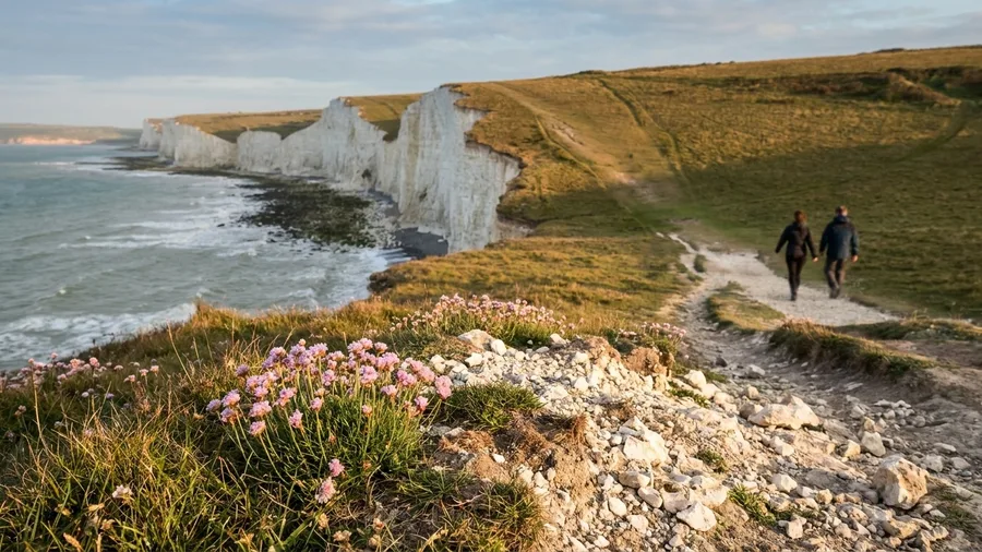
Take the Seven Sisters between the two coast-road bus stops and you get the whole white-cliff view for 4.5 miles and about 2.5 hours, one way, with nobody retracing a step.
You start at Birling Gap, climb once, steadily, and then it is grass clifftop the rest of the way to Cuckmere Haven – rolling chalk underneath, the sea below, the seven chalk backs of the cliffs folding away ahead. The coast bus links both ends hourly, so a single of €2 to €4 replaces a car, and the walk stays one way. The tea room at Birling Gap and the café at Cuckmere Haven are the only two places to eat, and there is no other food or shelter up on the clifftop, so a plate and a drink at €10 to €15 is the plan, not a fallback. Trainers with tread are enough; sheep graze on the path, so if you have a dog, keep it close. Go on a clear morning before 10am for the whitest cliffs and a parking space – May, June and September are the pick, and in July and August the car parks and viewpoints fill by 10. It is 4.5 miles and under 500 ft of ascent: the famous white cliffs fit inside a short-break morning.
💡 Tip: Walk it east to west and the sun stays behind you for most of the morning, which makes the cliffs look brighter.
A coastal walk is not a hike. It is a two-hour view with lunch at the end.
— What this list keeps proving
2. Cinque Terre's Via dell'Amore, Liguria
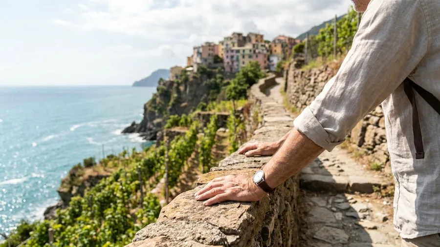
Yes – and without retracing your steps either, since the little train links all five villages if you ride the last leg back.
The honest catch is the fee. This is the one route here that charges for the walking itself; a park card covers the paid stretches, but prices and rules change, so check the official park and card sites before you go rather than trusting a number in an article. Manarola to Corniglia is 3.5 miles and about 2 hours, the shortest and lowest of the Ligurian village paths, on stone steps and paved path with handrails, threading terraced vineyards a few feet above the sea. You can be at the trailhead within a 10 to 30 minute walk or local bus ride of a village with a train station; a bus single is €2 to €4 and day parking €4 to €8.
Swim off Manarola's rocks first, then start by 8am in summer, because the path is narrow and the day-trippers convoy up by mid-morning. Climb the steps into Corniglia and eat focaccia at the top of them – a plate and a drink sits at €10 to €15, and you are eating within 15 minutes of the finish. May, June and September are best. Shoes with tread, one litre of water, a sun hat, an offline map.
💡 Tip: Swim off Manarola's rocks first, then buy focaccia at the top of the Corniglia steps. You'll have earned it.
| Walk | Distance and time | Underfoot | Getting there | Best months |
|---|---|---|---|---|
| Seven Sisters, East Sussex | 4.5 mi / 2.5 hr | Grass clifftop, chalk | Coast road bus between Birling Gap and Cuckmere Haven | May, Jun, Sep |
| Via dell'Amore, Liguria | 3.5 mi / 2 hr | Stone steps, paving | Village train; park card for paid stretches | May, Jun, Sep |
| Cliffs of Moher, Clare | 5 mi / 2.5 hr | Wide fenced path, flat | Bus from Ennis or Galway | May, Jun, Sep |
| Camí de Ronda, Catalonia | 4 mi / 2 hr | Steps, boardwalks | Half-hourly bus between S'Agaró and Sant Feliu | Jun, Sep |
| Path of the Lemons, Amalfi | 3 mi / 1.5 hr | Stone steps, handrails | Coastal bus or ferry between Minori, Maiori, Amalfi | May, Jun, Sep |
| Étretat, Normandy | 4.5 mi / 2 hr | Concrete stairs, clifftop | Le Havre–Fécamp bus line | May, Jun, Sep |
| Cape St Vincent, Algarve | 6 mi / 3 hr | Flat marked track | Bus between Sagres and the cape | May–Sep, winter sun |
| Ponta de São Lourenço, Madeira | 4.5 mi / 2 hr | Graded steps, gravel | Bus from Funchal, about 40 min | May, Jun, Sep |
| Giant's Causeway, Antrim | 2.5 mi / 1.5 hr | Paved, one steep section | Visitor centre shuttle; café on site | May, Jun, Sep |
| Calanques, Marseille | 5.5 mi / 3 hr | Rocky, waymarked | City bus to Callelongue | May, Jun, Sep |
3. The Cliffs of Moher cliff-top trail, County Clare
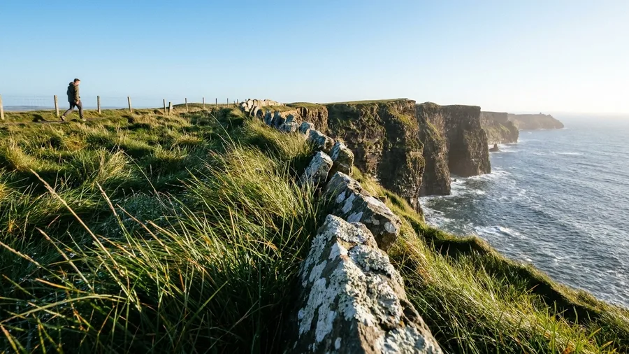
The wind hits you first, a low steady push off the Atlantic, and then the grass smell comes up from the cliff edge and you hear the gulls below, not above. The air runs 8 to 12°C cooler than the Mediterranean paths on this list, which means a light rain shell earns its place in your bag even on a bright morning. The Cliffs of Moher walk starts at the visitor centre and runs out to Hag's Head and back, 5 miles and about 2.5 hours.
This is the walk where you set your own distance. The trail is wide, fenced and mostly flat, so you walk as far as the weather allows and turn back whenever you like, with under 500 ft of ascent over the whole out-and-back. In a gust, step behind the low stone wall and wait it out. In fog, skip the cliff edge entirely; there is nothing to see and no reason to test the margin.
Can you do it without booking a tour? Yes, and the only cost beyond getting there is parking, €4 to €8 for the day. Walking is free. A bus from Ennis or Galway drops you at the visitor centre if you are coming by public transport, at a single fare of €2 to €4. Either way, you step off and start walking: no guide, no permit, no queue at a desk.
Carry your own water. The centre café is the only shelter and the only food for the entire stretch, so plan lunch for before or after rather than mid-route, when a café or village meal within 15 minutes of the finish runs €10 to €15 for a plate and a drink. May, June and September are the best months; in July and August, be on the path before 9am, because the car parks and viewpoints fill by 10.
Five miles, mostly flat, trainers with tread, one litre of water, a sun hat and an offline map on the phone. That is the whole kit for the biggest cliffs in Ireland, and the only variable you cannot control is the wind.
💡 Tip: The bus from Ennis or Galway drops you at the visitor centre door, so you can walk one way and ride back.
⚠️ COMMON MISTAKE
Don't pack for a mountain
Every route here is under 500 ft of ascent and done in trainers with tread. A heavy boot and a rucksack of layers will slow you down more than the climb will. One litre of water, a sun hat, a rain shell and an offline map covers all ten.
4. Catalonia's Camí de Ronda from S'Agaró
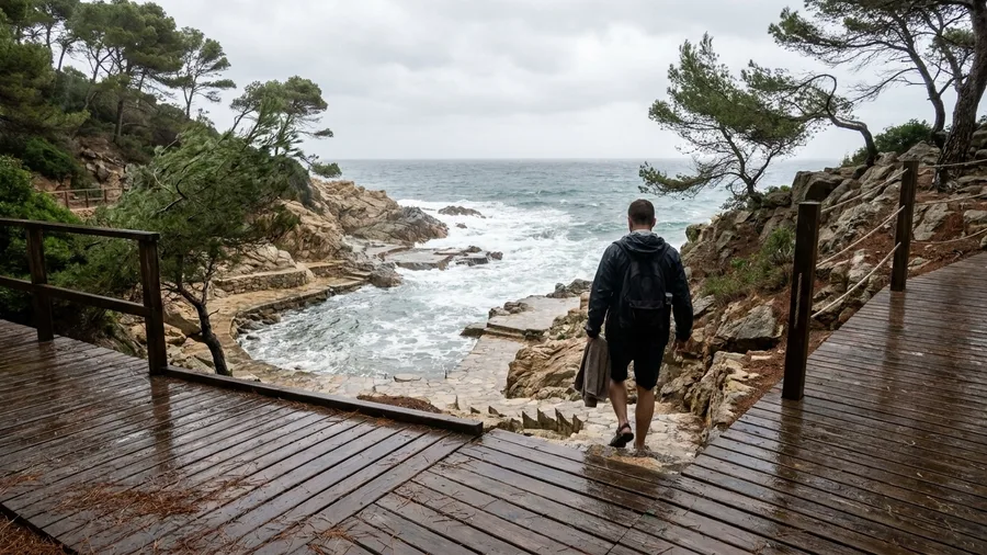
The Camí de Ronda is Catalonia's answer to a coast that asks you to swim halfway through.
Out of S'Agaró the path leaves the last villas and drops into umbrella pines, and for the next four miles it stays low: steps down to a cove, boardwalk across a gully, back up a dozen risers and down again to the water. Three signed coves sit off the main line, each a two-minute detour. Towel and swim things earn their place in the pack because they are used inside the two hours, not hauled around a full day of walking.
It runs point to point to Sant Feliu de Guíxols, and in summer a bus links the two towns roughly every half hour, so you walk one direction and ride back. Fares fall in the two- to four-euro band. In May, June and September the shade is generous and the coves are half empty; by July and August the pines stop helping around midday and the flat rocks at each inlet are claimed by eleven, so start before nine. Treaded shoes for the wet boardwalk, a litre of water, a hat and an offline map. Lunch waits within fifteen minutes of the harbour finish, a plate and a drink for ten to fifteen euros.
💡 Tip: The coves are pebble, not sand. Bring something to sit on and leave the flip-flops in the bag for the steps.
Camí de Ronda — At a Glance
📈 Elevation
Under 500 ft total ascent, never more than 40 ft at once
🎫 Permit or booking
None — walk it on the day
🅿️ Day parking
€4 to €8, either end
👟 Walk it in
Trainers with tread, nothing more
🌧️ Rain shell
Worth packing — this is the cooler Atlantic side of the peninsula, 8 to 12°C below the Med
Skip this walk if
You want a summit view — this route stays at sea level the whole way and the payoff is coves, not height.
5. The Path of the Lemons above Amalfi
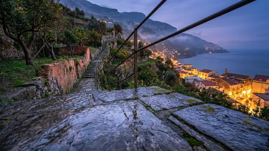
Three miles, ninety minutes, and the whole Amalfi Coast drama without the Path of the Gods climb.
The route is mostly stone stairways with handrails, cut through lemon terraces between Minori and Maiori. It finishes at sea level, which means lunch is a table on the seafront rather than a sandwich on a summit. Ferries and the coastal bus tie Minori, Maiori and Amalfi together, so the walk slots into a day already moving by boat – step off, climb, order. Buses cost two to four euros a single. Both towns run free water fountains, so refill there instead of buying bottles. May, June and September are best; in July and August go before nine.
One caution underfoot: the steps are polished by generations of feet and slick after rain, so grip matters more than cushioning. Trainers with tread will do. Carry a litre of water anyway, and a hat, and an offline map.
💡 Tip: Take the ferry back, not the bus, if the sea is calm. It costs a little more and gives you the coast from the water side.
6. Étretat's white-needle cliffs, Normandy
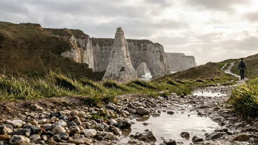
The Amalfi terraces end at a ferry; Étretat's cliffs end back in the same village, with two loops and the tide as your timetable.
The Amont and Aval circuits from the village centre add up to about 4.5 miles and roughly two hours, joining both to the waymarked GR21. The steep part is concrete stairs – short, brutal, over. Within twenty minutes of leaving the square you are standing above the chalk arch, looking down at it.
The food here is Norman and specific: a galette with cider in the village, or an ice cream eaten walking back up from the pebble beach, for around ten to fifteen euros. Eat before or after the walk rather than on the clifftop. Light is clearest early; the path crowds from late morning in summer. May, June and September are the pick, and in July and August be climbing by nine. If you want to stand under the arch rather than above it, time the walk to low tide. A light rain shell belongs in the pack whatever the forecast says.
💡 Tip: Check the tide table the night before. The arch is only walkable underneath at low water, and the tide comes in fast.
🗺️ How to plan any one of these walks
Pick by month
May, June and September work for every route; winter sun points you to Cape St Vincent.
Check the bus
Confirm the first and last return the night before, because a missed last bus doubles the walk.
Read the forecast
Wind shuts the São Lourenço path and fog ruins the Cliffs of Moher, so check before travelling out.
Pack four things
One litre of water, a sun hat, shoes with tread and an offline map on the phone.
Start by 9am
In July and August this beats the car parks, the coach groups and the midday heat.
Eat at the finish
Every route has a café or village lunch within 15 minutes for €10 to €15 a plate and a drink.
7. Cape St Vincent's clifftop loop, Algarve
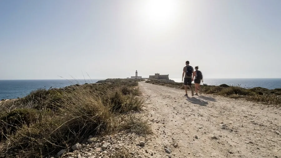
Before you commit to the sunset at the cape, know this: the buses back to Sagres thin out in the evening, and the last one leaves well before the light goes. Check the timetable at the Sagres stop in the morning, not on the clifftop at dusk with your phone dying.
The walk itself is a flat 6 miles out to Cabo de Sao Vicente and back, around 3 hours at an easy pace, on a marked track that never asks you to climb. Where the Normandy cliffs pack their drama into short loops and a village bus, this one stretches the day along the coast to Europe's south-western corner, a lighthouse and a fort sitting at the end of the land. January and February here run 15 to 18°C while the Mediterranean coast shivers, which is the whole reason locals walk it in winter rather than summer. If empty beaches matter as much as mild air, these small coastal towns in January trade summer crowds for cold and quiet. Bring a jacket against the wind, because the same Atlantic that keeps it mild also keeps it blowing; this coast sits 8 to 12°C cooler and windier than the Mediterranean routes, and a light rain shell earns its place in the bag even on a blue-sky day.
Getting there is simple. Buses connect Sagres and the cape a few times a day for a single of EUR 2 to EUR 4, so you can ride out and walk back, or the reverse. The catch is frequency, not cost, and the sunset timing is the one thing to plan around rather than improvise.
Food is the other gap. The cafe at the lighthouse and the harbour restaurants back in Sagres are the only places to eat, with nothing on the cliff between them, so carry water and don't count on a mid-walk snack. Eat a plate and a drink at the finish for EUR 10 to EUR 15, within 15 minutes of the trail's end.
May to September gives you the sunset itself, but the winter sun works too if you accept an earlier dusk. In July and August, be on the track before 9am, because the car parks and the viewpoint at the cape fill by 10. Any month, trainers with tread, a litre of water, a sun hat and an offline map cover it, and no guide or booking is needed at any point.
A sample walking week on a short break
8. Ponta de São Lourenço, Madeira
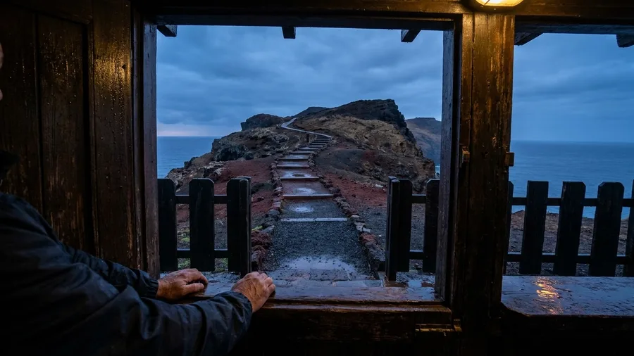
The wind hits first, then the smell of salt and dry thyme, and then the colour – red and black volcanic rock running out to sea at Madeira's eastern tip with nothing green to soften it.
That bare headland is the island's easiest dramatic coastal walk: a graded path of steps and gravel from Baía d'Abra to the kiosk at Casa do Sardinha, 4.5 miles out and back in about 2 hours with under 500 ft of ascent. It keeps the Atlantic exposure of the Algarve cape but drops the bus-timetable worry – the bus from Funchal takes about 40 minutes, singles €2 to €4, and parking at the trailhead fills by 10am in summer, so come early. The kiosk is the only refreshment on the route, and there is no shade anywhere; carry a litre of water, a sun hat and a rain shell, and check locally before travelling out, because the path sometimes shuts in high wind. May, June and September are the pick, and trainers with tread are all the footing you need.
💡 Tip: The path is sometimes closed in high wind. Check locally before travelling out, because the bus ride is long enough to waste a morning.
Which walk matches your group
Short and easy
- Giant's Causeway — 2.5 miles, shuttle for the hill back
- Path of the Lemons — 3 miles, handrails on the steps
- Via dell'Amore — 3.5 miles, train return
Bigger day, bigger view
- Cape St Vincent — 6 miles, flat, winter sun
- Calanques — 5.5 miles, rocky and exposed
- Cliffs of Moher — 5 miles, turn back whenever you like
9. The Giant's Causeway cliff path, County Antrim
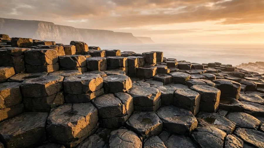
The Atlantic wind hits you first at the top of the descent, cold and salty, and the basalt columns below look like a staircase built for something much larger than a person. This is the shortest walk on the whole list, 2.5 miles and about 1.5 hours, partly paved with one steep section, and it costs nothing beyond the car park.
The centre's shuttle runs down to the stones, so a mixed-ability group can split and meet at the bottom, which is what makes it work for children or grandparents: under 500 ft of ascent and a ride back up the hill. There's a cafe and toilets at the centre, so plan lunch either before or after rather than mid-route, a plate and drink for EUR 10 to EUR 15. Come before 11am or after 3pm in summer, when the stones are thick with coach groups; May, June and September are best, and in July and August be there before 9am. It's an Atlantic route, 8 to 12°C cooler and windier than the Mediterranean, so bring a light rain shell, a litre of water, a sun hat and an offline map.
10. Marseille's Calanques coastal path
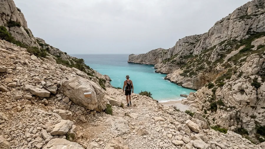
Arrive at the Sugiton beach after 11am in July or August and you will find no space to sit, let alone swim. The path out from Callelongue is fully exposed, so the hour you set off is the whole trip: be walking by 9am in high summer, and if you can, come in May, June or September instead, when the same limestone inlet is half empty at ten.
You reach the trailhead on a city bus from central Marseille, a ride of under half an hour for a single of €2 to €4, and the walk from there to Calanque de Sugiton and back is 5.5 miles, around three hours. The surface is rocky and waymarked, with one steep drop that asks for care, and it ends at water so turquoise it looks lit from below. Shoes with tread, a sun hat, an offline map and a light rain shell all earn their place in the pack.
The first calanque you pass has a strip of beach that serves as the half-way rest, and you should swim there and eat whatever you carried, because nothing between the trailhead and Sugiton sells food or water. Carry a full litre, and more if the forecast is hot. Some calanques east of the city need a free summer permit, so read the official national park site before you choose which stretch to walk. Back at Callelongue, a plate and a drink within fifteen minutes of the bus stop runs €10 to €15.
💡 Tip: Take the city bus from central Marseille and you arrive at the trailhead without parking stress. Singles run €2 to €4.
Frequently Asked Questions
Do I need hiking boots for these walks?
No. All ten are walkable in trainers, but the tread matters on chalk, polished stone steps and gravel. One litre of water, a sun hat, a rain shell and an offline map covers every route.
Can I do any of these without a car?
Yes, all ten. Every walk starts within a 10 to 30 minute walk or local bus ride from a town with a train station or ferry, and bus singles cost €2 to €4. Where day parking is charged it runs €4 to €8.
When is the best time to walk these routes?
May, June and September. In July and August be on the path before 9am because car parks and viewpoints fill by 10. For winter sun, Cape St Vincent in the Algarve gives mild 15 to 18°C days.
Is the Cinque Terre path free?
No. It is the only walk on this list that carries a path fee, and the park card covers the paid stretches. Check the official park and card sites for current rules before you go, because they change.
Are these walks suitable for children or grandparents?
The Giant's Causeway is the shortest and easiest at 2.5 miles, with a shuttle for the hill back. The Path of the Lemons and Via dell'Amore are also short with handrails or a train return. The longer routes, Cape St Vincent and the Calanques, are flat or graded but exposed.
Can I eat at the end of each walk?
Yes. Every route has a café or village lunch within 15 minutes of the finish, and a plate with a drink costs €10 to €15. A few routes, including the Cliffs of Moher and São Lourenço, have only one place to eat on the way, so carry water.
The One Walk to Take Home
Pick by situation. Anyone weighing a flat clifftop path at home can compare coastal walks in America with the same easy footing and parking details. With children or grandparents, take the Giant's Causeway: 2.5 miles, 1.5 hours, a shuttle down to the stones. Want the biggest cliffs with the least climbing? The Cliffs of Moher trail is 5 miles, wide, fenced and mostly flat. For winter sun, Cape St Vincent gives 15 to 18C days and a flat 6-mile cliff return. Save the Seven Sisters for a clear September morning, whitest before 10am.
That Seven Sisters day is the one to copy: bus stop to bus stop, Birling Gap to Cuckmere Haven, 4.5 miles, tea room at one end and cafe at the other.
Then do one thing the night before: check the local bus timetable and the wind or tide forecast, and be on the path by 9am. The best coastal view for a short break is the one that fits the day.
One walk, checked tonight, walked tomorrow
Open the bus timetable and the forecast now, pick the route that fits your group, and set an alarm for 8am. The coast will still be there; the parking space might not.